The Shortest Route | ||
| Description: | Calculates and plots the shortest route between two points on earth surface according to the World Geodetic System 1984 (WGS84). | |
| Filename: | wgs84.zip | |
| ID: | 6422 | |
| Current version: | 1.0 | |
| Author: | Radamés Romero Leyva | |
| Downloaded file size: | 7,982 bytes | |
| Size on calculator: | 7 KB | |
| Platforms: | 48 | |
| User rating: | Not yet rated (you must be logged in to vote) | |
| Primary category: | Science/Geography | |
| Languages: | ENG | |
| File date: | 2006-03-19 17:37:10 | |
| Source code: | Not included | |
| Download count: | 3,424 | |
| Version history: | 2006-03-19: Added to site | |
| Archive contents: |
| |
| Screenshot: | 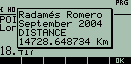 | |
| User comments: | Radamés Romero 2006-03-21 22:24:03 The program could last running until 7 minutes. The vertical axis on the route screen represents the Greenwich Meridian and the horizontal one the Equator. | |
You must be logged in to add your own comment. | ||